Statistical Analysis - Long Term Weather Estimation for Summer 2013 (Greece Region)
Date: 20 May 2013
STATISTICAL ANALYSIS - LONG TERM WEATHER PREDICTION - SUMMER 2013
Statistical analysis is a method of estimating weather for long periods. The model is based on the analysis of numerical data (temperature at 850hPa) which gives a statistical estimation / probability of weather trend during the estimated period.
Forecast for summer 2013:
General Trend
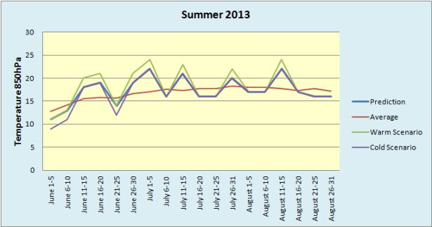
Summer trend in Greece based on a statistical sample of 34 years is appeared in the following graph:
The previous diagram shows that trend is constantly increased at a rate of 0,025 degrees Celsius / year.
Summer 2012 faced average temperature at 850hPa = 19 degrees Celsius. This was the warmest summer since the beginning of the sample and 2.3 degrees Celsius above the average climatic values (16.7 degrees Celsius at 850hPa).
Summer 2013 will face average temperature in 850hPa = 17,7 degrees Celsius which means that summer 2013 will be colder than summer 2012 by 1.3 degrees Celsius but warmer by 1 degree Celsius comparing to the average climatic values.
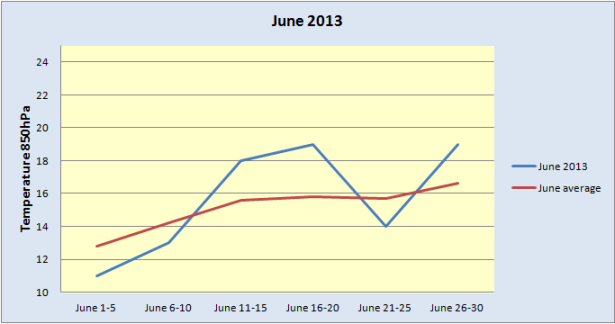
June 2013
- June 2013 is expected hotter than average climatic values by 0.5 degrees Celsius with average temperature at 850hPa = 15,7 degrees Celsius. June starts with lower temperatures (as normal for season) and increased chance of rain. However, gradually, temperature will be increased, reaching in the middle of June levels of 36-37 degrees Celsius. Following middle of June, temperature will be significantly decreased with increased chance of rain. Fall of June temperature will be increased again reaching levels of 36-37 degrees Celsius.
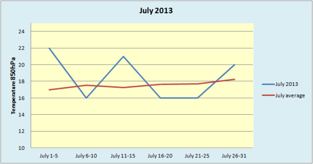
July 2013
- July 2013 is expected hotter than average climatic values by 1 degree Celsius with average temperature at 850hPa = 18,6 degrees Celsius.
July starts with the warmest days of summers and maximum temperatures reaching a level of 40-41 degrees Celsius. However, following the first days of July, temperature will be decreased with increased chance of rain at northern parts of mainland. Temperatures will be increased again in the middle of July reaching levels of 38-39 degrees Celsius. This warm period will be relatively short (maximum duration 2-3 days) followed by a cooler period with temperatures 6-8 degrees Celsius lower. These weather conditions are going to last till the end of month after which temperatures will be increases again reaching levels of 36-37 degrees Celsius.
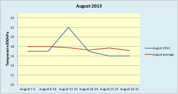
August 2013
- August 2013 will stand close to average climatic values with average temperature at 850hPa = 17,8 degrees Celsius.
August starts with lower temperatures (as normal for season) and reinforced breeze. These weather conditions will last until the week of Assumption during which temperature will be increased reaching levels of 39-40 degrees Celsius. However, following the week of Assumption temperatures will be decreased standing the last third of August in levels lower than normal for season with reinforced breeze.
In general summer 2013 is expected:
-Warm in feeling despite the breaks of dew.
-With more showers and thunderstorms as normal for season in mainland.
-With enhanced winds during August except the week of Assumption.
Dimitrios Kabolis
YouWeather.com
The above analysis is a weather estimation and not a weather forecast.
Data provided by the NOAA/OAR/ESRL PSD, Boulder, Colorado, USA, from their Web site at http://www.esrl.noaa.gov/psd/
Ημ/νία καταχώρησης: 20/5/2013
.png)